
When Crisis Hits, Local Government Doesn't Sleep
How the Maui kona storms of March 2026 revealed what real-time civic communication looks like — and why it matters.
4/7/20264 min read

A Storm That Refused to Leave
Kona lows are unusual weather systems — they develop south or southwest of the Hawaiian Islands and can stall, sometimes for days, drenching the islands with rainfall that causes flash flooding, landslides, and road damage. March brought not one but two of them to Maui County in quick succession, and the county’s communications team was posting through all of it.
The first storm triggered the emergency proclamation on March 10. Within forty-eight hours, the county was posting shelter information, bus service suspensions, road closure updates, and water supply advisories. Mayor Bissen began recording video updates that the county pushed to social media daily — sometimes more than once. By March 14, “STORM UPDATE” was appearing as a standalone post title, the kind of terse, urgent language that communicators reach for when there’s no time for nuance and people just need the facts.
“A powerful kona storm continues to hit Maui County, forcing widespread road closures from flooding, landslides, downed power lines…” — County of Maui, March 14, 2026
The community responded. Posts that might ordinarily earn modest attention were generating some of the highest engagement scores tracked anywhere across our 4,300-plus government units that month. Residents weren’t scrolling past — they were watching, sharing, commenting. When Maui Emergency Management Agency (MEMA) announced that the Emergency Operations Center in Wailuku was fully activated, people noticed.
Then the Second Storm Hit
Just as the first system began to ease — water conservation advisories lifted on March 18, bus routes resuming, roads slowly reopening — county officials were already watching a second kona low forming and tracking toward the islands. The posts shifted tone almost immediately: residents were urged to prepare again, to fill containers, to stay aware.
By March 21, the second storm had arrived in earnest. The Emergency Operations Center reactivated. Honoapiilani Highway closed. The ʻIao Valley and Wailuku River areas went under evacuation warnings. In a single afternoon, the county posted flash flood warning updates alongside evacuation advisories alongside a shelter relocation notice — all separate posts, all urgent, all within hours of each other. On March 21 and 22 combined, the county published seventeen posts. Nine on March 21 alone.
March 10-11: Emergency proclamation signed. Storm preparations begin. First shelter and water advisories posted.
March 12-15:Storm peak. Road closures, school closures, bus suspensions. Daily mayor video updates. Shelter information posted multiple times.
March 16-18:Recovery begins. Water advisories lifted. Roads clearing. County shifts to documenting damage and repair efforts.
March 19-20:Second kona low approaches. Flood watches issued. Residents urged to prepare again.
March 21-22:Second storm peaks. Evacuation warnings for ʻIāo Valley. Flash flood warnings. Seventeen posts in two days — all at peak engagement.
March 23-26: Evacuation warnings lifted. Damage assessment and reporting begins. Recovery communications continue.
The engagement data tells its own story. During the first storm, a Saturday update from Mayor Bissen earned five stars — the highest rating in our system. On March 21, MEMA’s 11:16 a.m. update reached five stars. On March 22, two separate posts — one on flash flood warnings, one on evacuation zones along the Wailuku River — both hit five stars. These aren’t posts that went viral because of clever copywriting. They went viral because people were scared and they wanted information, and the county was delivering it.
What This Looks Like From the Outside
Here’s the thing about a crisis like this: if you weren’t following Maui County’s social media feed in real time, you’d have no easy way to reconstruct what happened and when. News coverage exists, but it’s fragmented, filtered through reporters who couldn’t be everywhere, and often lacks the granular operational detail — the specific shelter that moved locations, the exact roads that reopened on which day, the precise timing of when evacuation warnings were lifted for which zones.
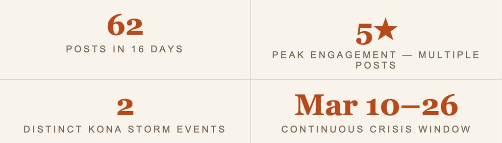
The county’s own posts contain all of that. Sixty-two data points across sixteen days, each one a timestamped record of what government was communicating to residents during a genuine emergency. That’s the kind of information that matters to emergency vendors assessing a government’s response posture, to journalists reconstructing a timeline, to researchers studying how local governments communicate under pressure, to insurers evaluating community resilience.
The county’s own posts contain all of that — a timestamped record of what government was communicating to residents during a genuine emergency.
And Maui County isn’t unique. Across the country, every day, local governments are posting updates that contain information most people never see because they’re not following four thousand different municipal Facebook pages. Flooding in one county, a major road closure in another, an emergency water main repair affecting a neighborhood — it’s all out there, it’s all public, and almost none of it makes it into any centralized, searchable, monitorable stream.
That’s the Gap GovFeeds Fills
We pull from over 4,300 government units every day. In March alone, that was more than 120,000 posts — weather emergencies and road closures and shelter activations and water supply alerts and all the other things local governments communicate constantly but that nobody has an easy way to watch all at once. The Maui storm generated sixty-two of those posts. Every one of them was in GovFeeds. Every one of them, in real time.
If you needed to know what was happening on Maui during the second week of March — not the news version, but the operational, government-direct version — GovFeeds had it. That’s not a small thing. During a crisis, the difference between knowing and not knowing can matter a great deal.
The March 2026 GovFeeds dataset includes posts from 4,318 government units across the United States. Engagement ratings (one through five stars) reflect audience interaction relative to each unit’s baseline.
Explore GovFeeds for Yourself: Get real-time access to public posts from thousands of local government units — searchable, filterable, and delivered as a data feed. publicsquareanalytics.com →
On the morning of March 10, 2026, Mayor Richard Bissen of Maui County signed an emergency proclamation. A powerful kona low storm — the kind of slow-moving, moisture-laden system that residents of the Hawaiian Islands know to respect — was bearing down on the island chain, and it wasn’t going anywhere fast. What followed over the next sixteen days was one of the most sustained local government communication surges we’ve seen tracked through our GovFeeds platform: sixty-two posts from a single county government, documenting a crisis as it unfolded hour by hour.
We spend a lot of time at Public Square Analytics thinking about what local government communication actually looks like in practice. Not the press releases and the ribbon cuttings — those are easy — but the messy, urgent, life-affecting stuff. Evacuations. Road closures. Shelters. Water supply disruptions. The moments when people genuinely need to know what their government is doing, right now, and whether it’s safe to go outside. The Maui kona storm story from last month is about as clear an illustration of that as we’ve seen.